
- 24
- Oct
Rae Town, Cornwall Courts being placed under Special Curfew
The areas of Rae Town in Kingston and Cornwall Courts in St. James are being placed under special area curfew. This will take effect from Friday, October 23 starting at 6:00 p.m. until 5:00 a.m. on Friday, November 6, 2020. During curfew hours, only essential workers with identification will be allowed to enter or exit. Additionally, the gathering limit will be no more than six (6) persons in any pub-lic place for the period. All the other existing restrictions such as mask wearing and physical distancing will be strictly enforced.
These two areas have seen an increase in COVID-19 cases, which is of great concern to the Health Authorities and thus this special measure is to restrict movement of persons to slow or prevent new exposures and hence new infections. There is also concern for the high population density of the two areas identified and the high vulnerability of persons within the areas to severe illness due to age, comorbidities and other socio-economic factors.
The Health Departments will be conducting the following activities in these areas:
- additional testing;
- close monitoring of members of the communities for development of symptoms;
- early containment of newly detected cases;
- prevention of new exposures and transmission of disease; and
- sensitisation of members of the communities regarding Infection Prevention and Control measures.
Enhanced Monitoring of Montego Bay Business District
Additionally, there will be enhanced monitoring and enforcement of the Dis-aster Risk Management Order in the business district of Montego Bay with spe-cial attention being given to markets, supermarkets, transportation centres, banks and business places.
The boundaries for the areas under special curfew are as follows:
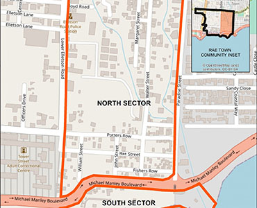
RAE TOWN NORTH SECTOR CURFEW AREA
The area of interest spans approximately 0.17 Sq. Km and is bound by a 1.79 km perimeter.
NORTH
The boundary will start at the four (4) way intersection with Upper Elletson Road, Lower Elletson Road, Victoria Avenue and Windward Road and run along Windward Road for approximately 0.37 km to the intersection with Paradise Street.
EAST
The boundary will continue in a southerly direction for approximately .56 km along Paradise Road, to the intersection with Michael Manley Boulevard; and continue farther south-easterly for approximately 0.17 km along an imaginary line which crosses the major gulley way south of Michael Manley Boulevard, to a point along the Kingston Harbour shoreline.
SOUTH
The boundary will continue westerly along the northern side of Michael Manley Boulevard for 0.35 km to a western point along the northern side of Michael Manley Boulevard.
WEST
The boundary will continue north for 0.2 km along an imaginary line from the western point along the northern side of Michael Manley Boulevard to the intersection of Lower Elletson Road and Rae Street; continue in a northerly direction along point at the four (4) way intersection with Upper Elletson Road, Lower Elletson Road, Victoria Avenue and Windward Road.
RAE TOWN SOUTH SECTOR CURFEW AREA
The area of interest spans approximately 0.04 Sq. Km and is bound by a 1.07 km perimeter.
NORTH
The boundary will start a point on the southern side Michael Manley Boulevard 0.2 km south of the intersection of Lower Elletson Road and Rae Street, then run for 0.44 km, crossing the major gulley way, south of Michael Manley Boulevard, to an eastern point along the southern side of the Michael Manley Boulevard.
EAST
The boundary will continue in a southerly direction for 0.17 km along an imaginary line along the major gulley way south of Michael Manley Boulevard, to a point along the Kingston Harbour shoreline.
SOUTH
The boundary will continue westerly along the Kingston Harbour shoreline for 0.61 km to a western point along the Kingston Harbour shoreline that is immediately to the Michael Manley Boulevard) terminating at the start a point on the southern side Michael Manley Boulevard.
CORNWALL COURTS CURFEW AREA
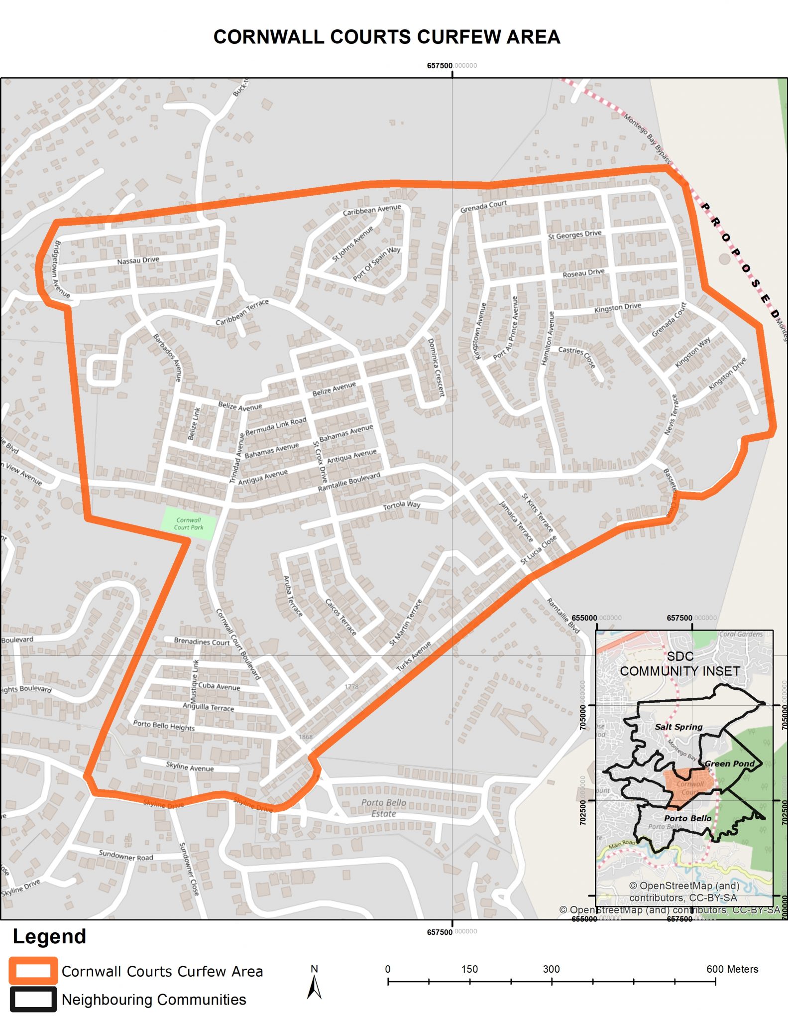
The area of interest spans approximately 1.01 Sq. Km and is bound by a 5 km perimeter.
SOUTH
The boundary will start at the intersection with Sunrise Drive and Skyline Drive and run along Skyline Drive for approximately 0.25 km to the round-about; continue northwesterly along Cornwall Courts Boulevard (Corner Courts Boulevard) for 0.04 km; continue northeasterly along an imaginary line parallel to Turks Avenue for 0.52 km to the intersection with Ramtallie Boulevard; and north along Ramtallie Boulevard for 0.12 km.
EAST
The boundary will continue in a northeasterly direction for approximately 0.94 km to the end of Basseterre Close along an imaginary line parallel and adjacent to Basseterre Close, Nevis Terrace, Kingston Drive, Havana Close and Grenada Close and encompassing all dwellings immediately adjacent thereto.
NORTH
The boundary will continue westerly along an imaginary line parallel to the Grenada Court, Caribbean Avenue and Bridgetown Avenue roadways for 1.62 km encompassing all dwellings immediately adjacent thereto, to a western point.
WEST
The boundary will continue south for 1.3 km along an imaginary line from the western point, encompassing all dwellings immediately adjacent to Bridgetown Avenue and Barbados Avenue, crossing Ramtallie Boulevard then terminate at the starting point at the intersection with Sunrise Drive and Skyline Drive and run along Skyline Drive.